by E. R. Heath, M.D.
(From “Kansas City Review of Science and Industry,” November, 1878)
On the Peruvian coast in ancient times, as now, nearly every structure was made of adobes or sun-dried brick, while in the mountains stone was used instead. The adobe ruins present nothing of beauty, architecturally. The subject for wonder is their immensity and number. Go where you will, relics of the past meet your eye either in ruined walls, water-courses, terraces, or extensive lands covered with the debris of pottery.
Take for example the Jequetepeque valley. In 7′ 24′ south latitude you will find on recent maps the port of Pacasmayo. Four miles north, separated from it by a barren waste, the river Jequetepeque empties into the sea. The bottom lands of the river are from two to three miles in width, with a southern sloping bank and the northern a perpendicular one nearly eighty feet high. Beside the southern shore, as it empties into the sea, is an elevated plat one fourth of a mile square and forty feet high, all of adobes. A wall fifty feet wide connects it with another, a few hundred yards east and south, that is 150 feet high, 200 feet across the top, and 500 at the base, nearly square. This latter was built in sections of rooms ten feet square at the base, six feet at the top and about eight feet high. These rooms were afterward filled with adobes, then plastered on the outside with mud and washed in colors.
All of this same class of mounds – temples, to worship the sun, or fortresses, as they may be – have on the north side an incline for an entrance or means of access. Treasure-seekers have cut into this one about half way, and it is said $150,000 worth of gold and silver ornaments were found. In the sand, banked up behind the wall and mound, many were buried, as the thousands of skulls and bones now exposed prove; thrown out by the hunter of huacos, as the pottery is called, huaca being the came given to these cemeteries. Each body has buried with it a vessel or water craft and a pot with grains of corn or wheat, and it is supposed the drinking vessel was filled with “chicha,” a fermented drink made from corn or peanuts. Beside these were many ornaments of gold, silver, copper, coral and shell beads and cloths.
On the north side of the river, on the top of the bluff, are the extensive ruins of a walled city, two miles wide by six long. Within the enclosure are the relics of two large reservoirs for fresh water. The clay from which these adobes were made was found at least six miles distant.
Follow the river to the mountains. All along you pass ruin after ruin and huaca after huaca. At Tolon, a town at the base of the mountains, the valley is crossed by walls of boulders and cobble stones, ten, eight and six feet high, one foot to eighteen inches wide at the top and two to three feet at the base, enclosing ruins of a city one-fourth of a mile wide and more than a mile long. The upper wall has projecting parts at the entrances, with port-holes, evidently serving as sentry boxes.
At this point the Pacasmayo Railroad enters the Jequetepeque valley. For eight miles back it crosses a barren sand plain of more than fifteen miles in length, covered with ruined walls, water courses, dead algaroba and espino trees, with fragments of pottery and sea shells, even to nine feet in depth mixed with the sand. The base of the mountains have, in good state of preservation, many thousand feet of an old water course, while their sides to the perpendicular parts are lined with terraces. This water course took its head from a ravine now dry, and, even beyond the memory of the oldest inhabitants, except in one or two cases, never carried water. It can be traced as far as Ascope, forty-five miles south.
Five miles from Tolon, up the river, there is an isolated boulder of granite, four and six feet in its diameters, covered with hieroglyphics. Fourteen miles further, a point of mountain at the junction of two ravines is covered to a height of more than fifty feet with the same class of hieroglyphics: Birds, fishes, snakes, cats, monkeys, men, sun, moon and many odd and now unintelligible forms. The rock on which these are cut is a silicated sandstone, and many of the lines are an eighth of an inch deep. In one large stone there are three holes, twenty to thirty inches deep, six inches in diameter at the orifice and two at the apex, and although polished as porcelain, these markings extend even to the bottom. The locality is of no importance; the stones as nature placed them; why, then, was so much labor and time expended upon them?
At Anchi, on the Rimac river, upon the face of a perpendicular wall two hundred feet above the river bed, there are two hieroglyphics, representing an imperfect B and a perfect D. In a crevice below them, near the river, were found buried twenty-five thousand dollars worth of gold and silver. When the Incas learned of the murder of their chief, what did they do with the gold they were bringing for his ransom? Rumor says they buried it, and many places are pointed out and thousands of dollars spent in useless search for the lost treasure. May not these markings at Yonan tell something, since they are on the road and near to the Inca city?
Eleven miles beyond Yonan, on a ridge of mountain seven hundred feet above the river, are the walls of a city of 2,000 inhabitants. A perilous ascent on hands and knees is now the only way to reach it; however, on the opposite side of the river are similar ruins, but easy of access. A remnant of a stone wall, ten and twelve feet high, built of small flat stones and without mortar, probably at one time served as river protection and against the tribe on the other side, there being a tradition that two powerful chiefs occupied these cities and were ever at war. The dead were buried in sepulchres, using large boulders as the top, while stone walls divided the space beneath into compartments.
Six and twelve miles further are extensive walls and terraces. Three miles north of the latter place are the rich silver mines of Chilete, formerly worked by the Indians, who left excavations two and three hundred feet deep, and must have taken out quantities of silver. A company with a paid-up capital of half a million is now working them.
Leaving the valley at seventy-eight miles from the coast, you zigzag up the mountain side 7,000 feet, then descend 2,000, to arrive at Cajamarca, or Coxamalca of Pizarro’s time. Here and there all the way you find relics of the past. In a yard off one of the main streets, and near the center of the city, is still standing the house made famous as the prison of Atahualpa, and which he promised to fill with gold as high as he could reach, in exchange for his liberty. Like all their stone work, the walls are slightly inclined inward, uncemented, built of irregular stones, each exactly faced to fit the next. The floor and porch are cut out of the solid stone, two and three feet deep, as the still intact remnants of stone pillars of the same rock show.
The hill from which the stone for the walls was taken is near by. On its top a large stone in the shape of a chair bears the name of “Inca’s chair,” and the Indians say it was the king’s custom to sit here every morning and salute the sun as it rose above the horizon. The two large places excavated out of the rock on the hillside, and now used as reservoirs for the city, were of ancient make. Three miles distant, and across the valley, are the hot springs, where the Inca was encamped when Pizarro took possession of Cajamarca. Part of the wall is of unknown make, (that encloses the baths.) Cemented, the cement is harder than the stone itself.
At Chocofan, nine miles from Pacasmayo, on the line of the railroad, a barren, rocky mountain, 1,200 feet high, is encircled four hundred feet from its top by a stone wall eight or ten feet high. From its northern side, running nearly northwest, is about five miles of the coast road of the Incas. Perfectly straight, it is twenty feet wide, and walled on both sides by round stones piled to a height of three and four feet, three feet wide at the base and two at the top, uncemented.
At Chepen, a station near the terminus of the branch of the Pacasmayo Railroad, is a mountain with a wall in many places twenty feet high, the summit being almost entirely artificial. In the sand at its base is one of Peru’s most extensive “huacas,” and from which some of the finest pottery and ornaments have been taken.
Fifty miles south of Pacasmayo, between the seaport of Huanchaco and Truxillo, nine miles distant, are the ruins of “Chan Chan,” the capital city of the Chimoa kingdom, which extended, when conquered by the Incas, from Supe to Tumbez, or over nearly the northern half of the coast of modern Peru. The road from the port to the city crosses these ruins, entering by a causeway about four feet from the ground, and leading from one great mass of ruins to another; beneath this is a tunnel. Be they forts, castles, palaces, or burial mounds called “huacas,” all bear the name “huaca.” Hours of wandering on horseback among these ruins give only a confused idea of them, nor can old explorers there point out what were palaces and what were not. To the right is the “Huaca of Toledo;” to the left, “Bishop’s Huaca.” The large square enclosures, shut in by wedge-shaped walls of adobe, twenty to twenty-five feet high, have nothing of an entrance into them that would be defined as a palace gate. A half a dozen of these, at least, are among the ruins. Within some of them are large square mounds or burying chambers, many of which have been opened and rifled of their contents. These are plastered at the ceilings.
Beside the so-called “huacas” already mentioned, there is another on the left side of the road called by the Spaniards “the Mass.” On many of the walls is some excellent stucco work. Excellent as regards the material of which it is made, more than with reference to its style of art. There is not a single grain of disintegration in the parts that surround the walls of the chamber, although it is half an inch high above the ordinary plaster in which it is done, nor the slightest impairment in its integrity during the many centuries it has stood exposed to the elements.
The highest enclosures – those of adobe brick, up to thirty feet, with a base of fifteen feet, on the right hand of the city as you advance toward Truxillo, between that town and the “Toledo huaca” – must have cost an immense amount of labor, and needed a large number of hands for their erection. Inside some of them, besides the square mounds, are narrow passages, not more than a yard in width. In others are squares, wherein are visible, though now filled with clay, the outlines of water tracks. On this side are the principal burial mounds, some having stairs of adobe.
In the city of Truxillo there exists in the records of the municipality a copy of the accounts that are found in the book of Fifths of the Treasury, in the years 1577 and 1578, referring to the “Huaca of Toledo.” The following is a condensed inventory:
First – In Truxillo, Peru, on the 22d of July, 1577, Don Garcia Gutierrez de Toledo presented himself at the royal treasury, to give into the royal chest a fifth. He brought a bar of gold nineteen carats ley and weighing two thousand four hundred Spanish dollars, of which the fifth, being seven hundred and eight dollars, together with one and a half percent to the chief assayer, were deposited in the royal box.
Second – On the 12th of December he presented himself with five bars of gold, fifteen and nineteen carats ley, weighing eight thousand nine hundred and eighteen dollars.
Third – On the 7th of January, 1578, he came with his fifth of large bars and plates of gold, one hundred and fifteen in number, fifteen to twenty carats ley, weighing one hundred and fifty-three thousand, two hundred and eighty dollars.
Fourth – On the 8th of March he brought sixteen bars of gold, fourteen to twenty-one carats ley, weighing twenty-one thousand one hundred and, eighteen dollars.
Fifth – On the 5th of April he brought different ornaments of gold, being little bells of gold and patterns of corn-heads and other things, of fourteen carats ley, weighing six thousand two hundred and seventy-two dollars.
Sixth – On the 20th of April he brought three small bars of gold, twenty carats ley, weighing four thousand one hundred and seventy dollars.
Seventh – On the 12th of July he came with forty-seven bars, fourteen to twenty-one carats ley, weighing seventy-seven thousand, three hundred and twelve dollars.
Eighth – On the same day he came back with another portion of gold and ornaments of cornheads and pieces of effigies of animals, weighing four thousand seven hundred and four dollars.
The sum of these eight bringings amounted to 278,174 gold dollars or Spanish ounces. Multiplied by sixteen gives $4,450,784 silver dollars. Deducting the royal fifth $985,953.75 – left $3,464,830.25 as Toledo’s portion.
Even after this great haul, effigies of different animals of gold were found from time to time. Mantles also, adorned with square pieces of gold, as well as robes made with feathers of divers colors, were dug up. There is a tradition that in the huaca of Toledo there were two treasures, known as the great and little fish. The smaller only has been found.
Between Huacho and Supe, the latter being one hundred and twenty miles north of Callao, near a point called Atahuanqui, there are two enormous mounds, resembling the Campana and San Miguel, of the Huatica valley, soon to be described.
About five miles from Patavilca (south and near Supe) is a place called “Paramonga,” or the fortress. The ruins of a fortress of great extent are here visible, the walls are of tempered clay, about six feet thick. The principal building stood on an eminence, but the walls were continued to the foot of it, like regular circumvallations; the ascent winding round the hill like a labyrinth, having many angles, which probably served as outworks to defend the place. In this neighborhood much treasure has been excavated, all of which must have been concealed by the pre-historic Indian, as we have no evidence of the Incas ever having occupied this part of Peru after they had subdued it.
From Lima north along the coast the Ancon & Chancay Railroad is built. Ancon, eighteen miles from Lima, is a favorite summer seaside resort. Just before reaching Ancon, the railroad runs through an immense burying-ground or “huaca.” Make a circuit of six to eight miles, and on every side you see skulls, legs, arms, and the whole skeleton of the human body, lying about in the sand. Legs attached to pelvis, and bent up, still with mummified skin on them; arms in the same state; relics of plaited straw, forming coffin swathes; pieces of net, of cloth, and many other such accompaniments of funeral accessories. Some water crafts of very superior quality have been obtained from these graves. Of these there are three different forms, in places separated a short distance from each other, but each style having its defined outline of locale. As to the shape of the graves, there are some of an inverted cylinder form, like that of a lime-kiln, the insides of which are lined with masonry work. In these the body is placed in the upright position. There is also the ordinary longitudinal grave, in which the corpse is right in contact with the earth. Likewise the grave cut square to a depth of six to eight feet, at the top of which, or within one or two feet of the surface of the ground, is a roofing or covering of mat work, placed on wooden rafters. In one of these Dr. Hutchinson, her Britannic Majesty’s Consul at Callao, found three bodies, all wrapped up together – being a man, woman and child their faces being swathed with llama wool instead of cotton, as is usually seen in ordinary ones. He also turned out relics of fishing nets, with some needles for making them, varieties of cloth, tapestry, and work-bags resembling ladies’ reticules. Not a vestige of vegetation about, nor sign of relic of the terraces mentioned by Prescott.
Whence came these hundreds and thousands of people who are buried at Ancon? How did they make out a living while on the earth? Time and time again the archaeologist finds himself face to face with such questions, to which he can only shrug his shoulders and say with the natives, “Quien sabe?” Who knows? At Pasamayo, 14 miles further “down north,” and on the sea shore, is another great burying ground. Thousands of skeletons lie about, thrown out by the treasure-seekers. It has more than a half mile of cutting through it for the Ancon & Chancay R. R. It extends up the face of the hill from the sea-shore to the height of about 800 feet, and being from a half to three-fourths of a mile in breadth, some idea may be formed of its extent.
Dr. Hutchinson, in two days, from these burial grounds, gathered 384 skulls, which, with specimens of pottery, he presented to Professor Agassiz and he to the Cambridge University, near Boston. Between the teeth he found pieces of copper as if for the Charon obolus, and one or two had plates of copper on their heads.
Crossing the brow of the hill, entering Chancay, and stretching toward the sea, are the remains of a six feet adobe wall. On the face of this hill, pointing to the line of the railway from Ancon, are two stone ditches, perfectly parallel and symmetrical, about 100 yards apart, and running from bottom to top to a height of about 300 yards. Between these are other lines of stone displaced, perhaps the ruins of some old terraces. All about this place, at the base of the hill, looking towards Chancay, as well as on the side in front of the sea, is full of graves; some are built up with stone walls, others lined inside with mudbricks, of no formation more than a heap of clay and water molded up in the hands and dried in the sun.
Over the hills of Chancay are quantities of small stones of different geological formation from the rock there. Dr. Hutchinson writes, under date of Oct. 30th, 1872, in an article to the Callao and Lima Gazette, now the South Pacific Times:
“I am come to the conclusion that Chancay is a great city of the dead, or has been an immense ossuary of Peru; for go where you will, on mountain top or level plain, or by the sea side, you meet at every turn, skulls and bones of all descriptions.”
Lima, the capital of Peru, is situated seven miles inland from Callao. Nine miles on the sea shore “up south,” is the city of Chorillos, the Long Branch of Peru. A railway connects Lima with these two cities, forming with the coast nearly a right angled triangle. This triangular ground is known as the Huatica Valley, and is an extensive ruin. Between Callao and Magdalena, four miles distant, there are seventeen mounds called “huacas,” although they present more the form of fortresses, residences or castles, than burying grounds. ‘Tis difficult to make out anything but fragments of walls, as the ground is mostly under cultivation. However, at various points, one can see that a triple wall surrounded the ancient city. These walls are respectively one yard, two yards, and three yards in thickness, being in some parts of their relics, from fifteen to twenty feet high.
To the east of these is the enormous mound called Huaca of Pando; and to the west, with the distance of about half a mile intervening, are the great ruins of fortresses, which natives entitle Huaca of the Bell. La Campana, the huacas of Pando, consisting of a series of large and small mounds, and extending over a stretch of ground incalculable without being measured, form a colossal accumulation. The principal large ones are three in number; that holding the name of the “Bell” is calculated to be 108 to 110 feet in height. At the western side, looking towards Callao, there is a square plateau with an elevation of about twenty-two to twenty-four feet, 95 to 96 yards north and south, east and west. At the summit it is 276 to 278 yards long, and 95 to 96 across.
On the top there are eight gradations of declivity, each from one to two yards lower than its neighbor; counting in direction lengthwise, the 1st plateau is 96 to 97 yards; 2nd plateau, 96 to 26 yards [sic]; 3rd plateau, 23 to 24 yards; 4th plateau, 11 to 12 yards; 5th plateau, 11 to 25 yards; 6th plateau, 23 to 24 yards; 7th plateau, 35 to 36 yards; 8th plateau, 35 to 37 yards; making the total of about 278 yards. For these measurements of the Huatica ruins I am indebted to the notes of J. B. Steere, Professor of Natural History and Curator of the Museum at Ann Arbor, Michigan.
The square plateau first mentioned, at the base, consists of two divisions, one six feet lower than the other, but each measuring a perfect square 47 to 48 yards; the two joining form the square of 96 yards. Beside this, and a little forward on the western side, is another square 47 to 48 yards. On the top, returning again, we find the same symmetry of measurement in the multiples of twelve, nearly all the ruins in this valley being the same, which is a fact for the curious. Was it by accident or design?
In its breadth from north to south, three levels are found. The first lower down, 17 to 18 yards wide; the second or highest summit, 59 to 60 yards across; and the third descent again, 23 to 24 yards. The mound is a truncated pyramidal form, and is calculated to contain a mass of 14,641,820 cubic feet of material. For the most part, this great work is composed of adobes, each six inches long, four inches wide, and two and a half inches thick, many having the marks of fingers on them. But this does not consist of more than one-third of the Pando huaca.
Walking down past the southern corner, where the adobes are tumbled into a conglomerate mass by some earthquake, we see skulls with bones of arms and legs, cropping up in many places. The same adobe work is visible throughout, and the whole length of these structures ranges between seven and eight hundred yards.
The “Fortress” is a huge structure, 80 feet high, 148 to 150 yards in measurement. Great large square rooms show their outlines on the top, but are filled with earth. Who brought this earth here, and with what object was the filling up accomplished? The work of obliterating all space in these rooms with loose earth must have been almost as great as the construction of the building itself.
About two miles south of the last named large fort, and in a parallel line with it as regards the sea, we find another similar structure, probably a little more spacious and with a greater number of apartments, or divisions by walls, on the top of which we can now walk, as it is likewise filled up with clay. This is called “San Miguel.” It is nearly 170 yards in length, and 168 in breadth, and 98 feet high.
The whole of these ruins, big fortress, small forts and temples, were enclosed by high walls of adobones, but all of wedge-shaped form, with the sharp edge upward. Adobones are large mud bricks, some from one to two yards in thickness, length and breadth.
The huaca of the “Bell” contains about 20,220,840 cubic feet of material, while that of “San Miguel ” has 25,650,800. These two buildings were constructed in the same style – having traces of terraces, parapets, and bastions, with a large number of rooms and squares – all now filled up with earth.
Near Lima, on the south, is another mound, 70 feet high and 153 yards square. Near the residence of Par Soldan, the Geographer of Peru, is a mound called “Sugar Loaf,” or “San Isidro,” 66 feet high, 80 yards broad at the base, and 130 yards long. Professor Raimondi, the naturalist, chemist and scientist, who is doing for Peru what Gay did for Chili, said he found nothing in it but bodies of ordinary fishermen, relics of nets, and some inferior specimens of pottery. Prof. Steere and Dr. Hutchinson turned out about forty skulls, some bits of red and yellow dyed thread, being relics of cloth; a piece of string made of woman’s hair, plaited, about the size of what is generally used for a watch guard; and pieces of very thick cotton cloth, bits of fish nets, portions of slings, and two specimens of crockery ware of excellent material.
About a mile beyond, in the direction of “Mira Flores,” is Ocharan, the largest burial mound in the Huatica valley. This mound presents, as it is approached, the appearance of an imposing and enormous structure. It has 95 feet of elevation in its highest part, with an average width of 55 yards on the summit and a total length of 428 yards, or 1,284 feet, another multiple of twelve. It is inclosed by a double wall 816 yards in length by 700 across, thus enclosing 117 acres.
Between Ocharan and the ocean are from 15 to 20 masses of ruins, like those already described.
Fifteen miles south of Lima in the valley of Lurin, and near the sea, are the ruins of Pacha Camac, the Inca temple of the sun. Like the temple of Cholula on the plains of Mexico, it is a sort of made mountain or vast terraced pyramid of earth. It is between two and three hundred feet high, and forms a semi-lunar shape, that is beyond a half mile in extent. Its top measures about ten acres square. Much of the walls are washed over with a red paint, probably ochre, and are as fresh and bright as when centuries ago it was first put on. In these walls in three or four places, are niches, apparently of the same shape and size as we see in the ruins of Pagan temples. From one side, going toward the north, are the relics of a wall, which is covered with soot, possibly the remnant of fires to make sacrifices, and nothing can better illustrate the conservative tendency of the Peruvian climate than the fresh appearance of the soot. Prescott says of Pacha Camac, that it was to the Peruvians what Mecca is to the Mahometan, and Cholula was to the Mexican.
In the Canete valley, opposite the Chincha Gaano Islands, are extensive ruins. In that region a terra-cotta mask was found similar to that of which there is a drawing in Mr. Squiers’ report of his explorations in the State of New York, and discovered while excavating for the St. Lawrence canal. From the hill called “Hill of Gold,” copper and silver pins were taken like those used by ladies to pin their shawls; also, tweezers for pulling out the hair of the eye-brows, eye-lids and whiskers, as well as silver cups. Buried 62 feet under the ground on the Chincha Islands, stone idols and water pots were found, while 35 and 33 feet below the surface were wooden idols.
Beneath the Guano on the Guanapi Islands, just south of Truxillo, and Macabi just north, mummies, birds and bird’s eggs, gold and silver ornaments were taken. On the Macabi the laborers found some large valuable golden vases, which they broke up and divided among themselves, even though offered weight for weight in gold coin, and thus have relics of greatest interest to the scientist been forever lost. He who can determine the centuries necessary to deposit thirty and sixty feet of guano on these islands, remembering that, since the conquest three hundred years ago, no appreciable increase in depth has been noted, can give you an idea of the antiquity of these relics.
The coast of Peru extends from Tumbez on the north to the river Loa on the south, a distance of 1,235 miles. Scattered here and there over this whole extent, there are thousands of ruins beside those just mentioned, and similar, only not so extensive; while nearly every hill and spur of the mountains have upon them or about them some relic of the past; and in every ravine from the coast to the central plateau, there are ruins of walls of fortresses, cities, burial vaults, and miles and miles of terraces and water courses. Across the plateau and down the eastern slope of the Andes to the home of the wild Indian, and into the unknown, impenetrable forest, still you find them.
In 1861, Mendoza, in the Argentine Republic, a beautiful city on the plain, 45 miles from the foot of the Andes, in the short space of five minutes was a complete ruin, and 15,000 out of her 20,000 inhabitants, or 75 percent, were in the arms of death. In 1871 it was still exactly as on the evening of her destruction; the miles of skeletons lying uncovered where they perished, and the streets yet obstructed with the debris of the fallen walls of the houses. A new city has been built beside the old one. Seeking a photograph of the ruins, I was told there were none. Persuading one of the artists to take some views of them, and going to see the proof, he told me he had been out all day and had done nothing, as he could find nothing to take “but a pile of dirt.” Thus, also, you might, as most do, style these coast ruins, and those who live among them understand and appreciate them no better than did the Mendoza artist the ruins of that ill-fated city.
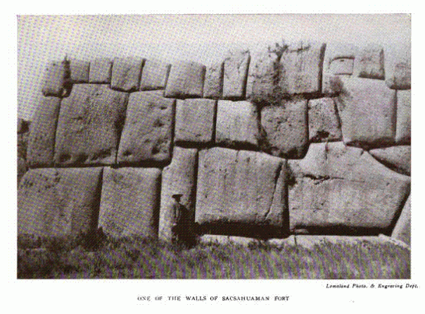
In the mountains, however, where storms of rain and snow with terrific thunder and lightning are nearly constant a number of months each year, the ruins are different. Of granitic, porphyritic, lime and silicated sandstone, these massive, colossal, cyclopean structures have resisted the disintegration of time, geological transformations, earthquakes, and the sacrilegious, destructive hand of the warrior and treasure-seeker. The masonry composing these walls, temples, houses, towers, fortresses, or sepulchres, is uncemented, held in place by the incline of the walls from the perpendicular, and adaptation of each stone to the place destined for it, the stones having from six to many sides, each dressed, and smoothed to fit another or others, with such exactness that the blade of a small pen knife cannot be inserted in any of the seams thus formed, whether in the central parts entirely hidden, or on the internal or external surfaces. These stones, selected with no reference to uniformity in shape or size, vary from one-half cubic foot to 1,500 cubic feet solid contents, and if, in the many, many millions of stones you could find one that would fit in the place of another, it would be purely accidental.
In “Triumph street,” in the city of Cuzco, in a part of the wall of the ancient house of the virgins of the sun, is a very large stone, known as “the stone of the twelve corners,” since it joins with those that surround it, by twelve faces, each having a different angle. Beside these twelve faces it has its external one, and no one knows how many it has on its back that is hidden in the masonry. In the wall of the center of the Cuzco fortress there are stones 13 feet high, 15 feet long, and eight feet thick, and all having been quarried miles away.
Near this city there is an oblong smooth boulder 18 feet in its longer axis, and 12 in its lesser. On one side are large niches cut out, in which a man can stand, and by swaying his body cause the stone to rock. These niches apparently were made solely for this purpose.
One of the most wonderful and extensive of these works in stone, is that called Ollantay-Tambo, a ruin situated thirty miles north of Cuzco, in a narrow ravine on the bank of the river Urubamba. It consists of a fortress constructed on the top of a sloping, craggy eminence. Extending from it to the plain below, is a stone stairway. At the top of the stairway are six large slabs, twelve feet high, five feet wide, and three feet thick, side by side, having between them and on top narrow strips of stone about six inches wide, frames as it were to the slabs, and all being of dressed stone.
At the bottom of the hill, part of which was made by hand, and at the foot of the stairs, a stone wall ten feet wide and twelve feet high extends some distance into the plain. In it are many niches, all facing the south.
The ruins on the islands in Lake Titicaca, where Incal history begins, have often been described. At Tiahuanaco, a few miles south of the lake, there are stones in the form of columns, partly dressed, placed in line at certain distances from each other, and having an elevation above the ground of from eighteen to twenty feet. In this same line there is a monolithic doorway, now broken, ten feet high by thirteen wide. The space cut out for the door is seven feet four inches high, by three feet two inches wide. The whole face of the stone above the door is engraved. Another, similar, but smaller, lies on the ground beside it. These stones are of hard porphyry, and differ geologically from the surrounding rock, hence, we infer they must have been brought from elsewhere.
At “Chavin de Huanca,” a town in the province of Huari, there are some ruins worthy of note. Entrance to them is by an alley-way six feet wide and nine feet high, roofed over with sand-stone partly dressed, of more than twelve feet in length. On each side there are rooms twelve feet wide, roofed by large pieces of sandstone one and a half feet thick and from six to nine feet wide. The walls of the rooms are six feet thick, and have some loop-holes in them, probably for ventilation. In the floor of this passage there is a very narrow entrance to a subterranean passage that passes beneath the river to the other side. From this many huacos, stone drinking vessels, instruments of copper and silver, and a skeleton of an Indian sitting, were taken. The greater part of these ruins are situated over aqueducts. The bridge to these castles is made of three stones of dressed granite, twenty-four feet long, two feet wide by one and a half thick. Some of the granite stones are covered with hieroglyphics.
At Corralones, twenty-four miles from Arequipa, there are hieroglyphics engraved on masses of granite, which appear as if painted with chalk. There are figures of men, llamas, circles, parallelograms, letters, as an R and an O and even remains of a system of astronomy. At Huaytar, in the Province of Castro Virreina, there is an edifice with the same engravings.
At Nazca, in the Province of Ica, there are some wonderful ruins of aqueducts, four to five feet high and three feet wide, very straight, double walled, of unfinished stone, flagged on top.
At Quelap, not far from Chochapayas, there have lately been examined some extensive works. A wall of dressed stone 560 feet wide, 3,660 long, and 150 feet high. The lower part is solid. Another wall above this has 600 feet length, 500 width, and the same elevation of 150 feet. There are niches over both walls, three feet long, one and a half wide and thick, containing the remains of those ancient inhabitants, some naked, others enveloped in shawls of cotton of distinct colors, and well embroidered. Their legs were doubled so that the knees touched the chin, and the arms were wound about the legs.
The wall has three uncovered doors, the right side of each being semicircular, and the left angular. From the base an inclined plane ascends almost insensibly the 150 feet of elevation, having about mid-way a species of sentry box in stone. In the upper part there is an ingenious hiding place of dressed stone, having upon it a place for an outlook from which a great portion of the Province can be seen. Following the entrances of the second and highest wall, there are other sepulchres like small ovens, six feet high and twenty-four in circumference, in their base are flags, upon which some cadavers reposed.
On the north side there is, on the perpendicular rocky side of the mountain, a brick wall, having small windows 600 feet from the bottom. No reason for this, nor means of approach, can now be found. The skillful construction of utensils of gold and silver that were found here, the ingenuity and solidity of this gigantic work of dressed stone, make it, also, probably pre-Incal date.
To support the inhabitants, it became necessary to cultivate every part of the land possible, and since the greater portion is mountainous, they could make no use of that land except by such means as they adopted, i.e., by terraces. Along the side, at the base of a hill or mountain, a stone wall is laid from one to eight feet high, according to the slope, and earth filled in between it and the side of the mountain, till even with the wall. Having this level for a base, another wall is laid, and again earth tilled in, and so on, tier above tier, as high as the place will permit. These are terraces.
The summits of the mountains are saturated with water from the melting snow or winter rains. This, forming little streams, is guided over these terraces. Each terrace is divided into patches by making a little ridge of earth a few inches high all around them, enclosing places two feet by six, or eight feet by ten, and so on according to the size of the terrace. The top terrace is first flooded, the ridge of earth serving as a dam. When it is considered wet enough, a channel is made by taking out a part of the ridge (with the hand or a little paddle about the size of a pancake turner) permitting the water to escape to the part below, flowing over the wall to the next terrace, which is similarly treated.
But there are thousands of terraces where the mountains and hills are so low and near the rainless portion that snow never, and rain, very seldom, moistens their summits, and where no one could expect water for irrigation unless carried there by hand. Starvation alone would compel people to undertake so fatiguing and laborious a work, especially in a country where the evenness of the climate tends to relax the energy of both mind and body.
Estimating five hundred ravines in the twelve hundred miles of Peru, and ten miles of terraces of fifty tiers to each ravine, which would only be five miles of twenty-five tiers to each side, we have 250,000 miles of stone wall, averaging three to four feet high – enough to encircle this globe ten times. Surprising as these estimates may seem, I am fully convinced that an actual measurement would more than double them, for these ravines vary from thirty to one hundred miles in length, and ten miles to each is a low estimate.
While at San Mateo, a town in the valley of the river Rimac, seventy-seven miles from the coast, where the mountains rise to a height of fifteen hundred or two thousand feet above the river bed, I counted two hundred tiers, none of which were less than four and many more than six miles long. Even at four miles, there would be at that point alone eight hundred miles of stone wall, and that only on one side of the ravine.
Who, then, were these people, cutting through sixty miles of granite, transporting blocks of hard porphyry, of Baalbic dimensions, miles from the place where quarried, across valleys thousands of feet deep, over mountains, along plains, leaving no trace of how or where they carried them; people ignorant of the use of iron, with the feeble llama their only beast of burden; who, after having brought these stones together and dressed them, fitted them into walls with mosaic precision; terracing thousands of miles of mountain side; building hills of adobes and earth, and huge cities; leaving works in clay, stone, copper, silver, gold and embroidery, many of which cannot be duplicated at the present age; people apparently vying with Dives in riches, Hercules in strength and energy and the ant and bee in industry?
Callao was submerged in 1746 and entirely destroyed. Lima was ruined in 1678, in 1746 only twenty houses out of three thousand were left standing – and again injured in 1764, 1822 and 1828, while the ancient cities in the Huatica and Lurin valleys still remain in a comparatively good state of preservation. San Miguel de Piura, founded by Pizarro in 1531, was entirely destroyed in 1855, while the old ruins near by suffered little. Arequipa was thrown down in August, 1868, but the ruins near show no change.
Spanish writers refer all to Incal make, but Incal history only dates back to the eleventh century, and from that time to the Conquest is insufficient, nor do they speak of many of these works. It is granted that the Temple of the Sun, at Cuzco, was of Incal make, but that is the latest of the five styles of architecture visible in the Andes, each probably representing an age of human progress; therefore we are pretty certain that the imperial glories of the Incas were but the last gleam of civilization that mounted up to thousands of years; that long before Manco Capac, the Andes had been the dwelling place of races whose beginnings must have been coeval with the savages of Western Europe.
The gigantic architecture points to the Cyclopean family, the founders of the Temple of Babel and the Egyptian Pyramids. The Grecian scroll found in many places, borrowed from the Egyptians; the mode of burial and embalming their dead, points to Egypt as their similar, while the distaff, plow, manner of threshing and of making brick the same as when the Israelites were captives.
The hieroglyphics, to none of which as yet a key has been found, cannot be referred to the Incas, since they apparently had no knowledge of characters, but kept their records and accounts by means of a quippus, or knots and different colored threads, as did those in Asia, China, Mexico and Canada, in ancient times, and they kept in each city an official whose business it was to keep and decipher their quippus. It was made of twisted wool, and consisted of a thread or thick string, from one to eighteen feet long, as a base upon which other threads or strings were attached. The different colors had different significations: the red, soldier or warrior; the yellow, gold; the white, silver or peace; the green, wheat or corn, and so on. In numerals, one knot signified ten; two simple knots, twenty; the knot doubly interlaced, one hundred; trebly interlaced, one thousand; two interlacings of this latter, two thousand.
By setting apart a quippus for the military, another for laws and decrees, another for historic events – i.e., a separate quippus for distinct classes of ideas – the same knots could be used many times over, but to read them one must know to which class they belonged. Certain signs were affixed to the beginning of each “mother-thread,” as the base or principal string was called, by which the official could distinguish each; however, should an official visit another locality, these signs had to be explained verbally, also the signs representing local events, names of rivers, mountains, ships, cities, etc. Hence, a quippus was only intelligible, for the most part, in the place it was kept.
Many quippus have been taken from the graves, in excellent state of preservation in color and texture, but the lips that alone could pronounce the verbal key have forever ceased their function, and the relic seeker has failed to note the exact spot each was found, so that the records which could tell so much we want to know, will remain sealed till all is revealed at the last day.
The skulls taken from the burial-grounds, according to craniologists, represent three distinct races. The first, to which the name “Chinchas” has been given, occupied the western part of Peru from the Andes to the Pacific, and from Tunebez on the north to the desert of Atacama on the south. The second, called “Aymaras,” dwelt in the elevated plains of Peru and Bolivia, on the southern shore of lake Titicaca, where they reside even to this day, being the only race that did not give up their language for the Inichua, or language of the Incas, when conquered by them. The third, called “Huancas,” occupied the plateau between the chains of Andes north of lake Titicaca to the 9th degree of south latitude.
This race were supposed to have caused the peculiar shape of their heads by mechanical means, as the Flat head Indians with us, and the Combos, a tribe that now live on the banks of the Ucayali near Sarayacu, but the taking from a mummy of a foetus of seven or eight months having the same configuration of the skull, has placed a doubt as to the certainty of this fact.
How changed! How fallen from their greatness must have been the Incas when a little band of 160 men could penetrate uninjured to their mountain homes, murder their worshiped kings and thousands of their warriors, and carry away their riches, and that, too, in a country where a few men with stones could resist successfully an army! Who could recognize in the present Inichua and Aymara Indians their noble ancestry?
Their songs are typical of their condition, and are called “tristes,” or sad songs. Always a duet in a minor key, and at night as you hear it, it seems rather the expiring wail of some lost spirit than a human voice. It begins with a full inspiration of the lungs and at the highest pitch of the voice, and ends with the expiration of the breath in a low, long drawn out “andante pianissimo.” The words are chanted and often made up for the occasion.
These are the words heard by a traveler from the lips of a young Indian mother, in the wild recesses of the Andes:
“My mother begat me amid rain and mist, To weep like the rain and be drifted like the clouds. You are born in the cradle of sorrow, Says my mother; and she weeps as she wraps me around.
“If I wander the wide world over, I could not meet my equal in misery. Accursed be the day of my birth, Accursed be the night I was born, From this time, for ever and ever!”
Three times the Andes sank hundreds of feet beneath the ocean level, and again were slowly brought to their present height. A man’s life would be too short to count even the centuries consumed in this operation. The coast of Peru has risen eighty feet since it felt the tread of Pizarro. Supposing the Andes to have risen uniformly and without interruption, seventy thousand years must have elapsed before they reached their present attitude.
Who knows, then, but that Jules Verne’s fanciful idea regarding the lost continent Atlanta may be near the truth? Who can say that where now is the Atlantic ocean, formerly did not exist a continent, with its dense population, advanced in the arts and sciences, who, as they found their land sinking beneath the waters, retired, part east and part west, populating thus the two new hemispheres? This would explain the similarity of their archaeological structures and races and their differences, modified by and adapted to the character of their respective climates and countries. Thus could the llama and camel differ, although of the same species; thus the algoraba and espino trees; thus the Iroquois Indians of North America and the most ancient Arabs call the constellation of the “Great Bear” by the same name: thus various nations, cut off from all intercourse or knowledge of each other, divide the Zodiac in twelve constellations, apply to them the same names, and the northern Hindoos apply the name Andes to their Himalayan mountains, as did the South Americans to their principal chain.
Must we fall in the old rut and suppose no other means of populating the Western Hemisphere except “by way of Behring’s strait?” Must we still locate a geographical Eden in the East, and suppose a land equally adapted to man and as old geologically, must wait the aimless wanderings of the “lost tribe of Israel” to become populated?
Beside dead and speechless relics of the past, there exists a living antiquity. In 7′ south latitude, a couple of miles from the sea, there is a town of about 4,000 inhabitants called Eten. They speak, besides the Spanish, a language that some of the recently brought over Chinese laborers understand, but differ in all other respects. They intermarry brothers and sisters, uncles and nieces, nephews and aunts, i.e. promiscuously, with no apparent curse of consanguinity. They are exclusive, permitting no intermarriage into their number or with the outside world. They have laws and customs and dress of their own, and live by braiding hats, mats, and weaving cloths. They will give no account of when they came or from whence, nor does history mention them as existing before the Spaniards came, nor does it record their arrival since.
Among them you will find no sick or deformed people, their custom being to send a committee to each sick or old person, and if they judge the patient past recovery or the aged past usefulness, the public executioner is sent and they are strangled. Eten orders it, they say, and none ever interfere with these orders.
Thirteen thousand years ago, Vega, or a. Lyrae, was the north polar star. Since then how many changes has she seen in our planet? How many nations and races spring into life, rise to their zenith splendor and then decay; and when we shall have been gone thirteen thousand years, and once more she resumes her post at the north, completing a “Platonic, or Great Year,” think you that those who shall fill our places on the earth at that time will be more conversant with our history than we are of those that have passed? Verily might we exclaim in terms almost Psalmistic, Great God, Creator and Director of the Universe, – what is man that Thou art mindful of him!
—————-